Click the scene thumbnails below to access full views and detail sections.
|
Clicking any of the thumbnail images takes the viewer to a page featuring the corresponding full-size overall scene, nearly 9 inches wide. From that page, the first of a series of close-up views showing detailed sections of that scene can be accessed. Using "next" and "previous" navigationals, the viewer can proceed through the several overall scenes and their respective close-up sections. Or the viewer can click on a link listed on any of the overall scene pages and close-up section pages to return to this starter page.
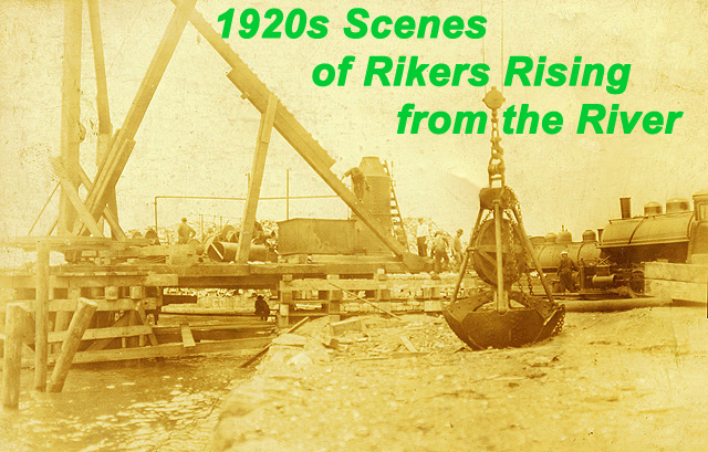
Below are interesting tidbits about how most of Rikers Island rose from the river: New York City’s municipal government included landfill expansion in its plans for Rikers Island even as the city fathers went about acquiring the East River marshy islet in 1884.
“That scheme includes the reclamation of a great deal of land belonging to Rikers Island and bought with it.” The U.S. Coast Survey was cited as reporting that • Of the island’s 87.5 acres, nearly a half – 43.2 – were less than three feet above the high water mark.
• Those figures were said to make 481.5 acres the “practical” size to set as the target for the island’s land development.
“The Commissioners have already learned from experience that they can construct cribwork of best quality for less than 4 cents per cubic foot.” Rikers Island was not the first landfill involvement for the city's correctional ageny. Blackwell's Island (now known as Roosevelt Island), purchased in 1828 to house various municipal penal and charitable institutions, had island shaping touches applied to it -- the land was made to slope toward the water and a sea-wall was erected.
Inmate labor was seen as a major cost reducing factor in planning the project.
Of course, that estimate might have seemed to suggest that reaching 481.5 acres for the island’s total size would take only a few years. Actually the work spanned more than a half century. While NYC Correction staffers and ex-staffers, whether uniformed or civilian, are well aware that Rikers Island is mostly man-made, having been been expanded more than fourfold from solid waste dumping and leveling, far fewer realize the extensive role that other landfill operations have played in the city's penal history.
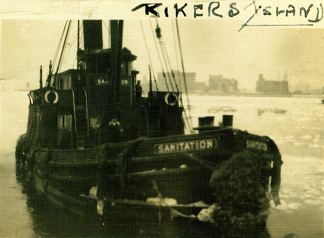
According to the Reconnaissance Mapping of Landfills in New York City study by environmental remediation expert and Columbia University professor, Dr. Daniel C. Walsh: “For the first 15 years of the 20th century, numerous landfills fed by barge-loads of waste from Manhattan and the western Bronx are identified in the [landfill] literature [study]. Barge-fill sites are identified in figure 3 in the Bronx (Rikers Island, Hart Island and Cromwell Creek) . . . .
"During the 1930s, 17 million cubic yards of waste fill was transferred from Rikers Island to northern Queens to build LaGuardia Airport. The 1934 World Fair site was built on 1,200 acres of filled wetland in Flushing, Queens. . . ”Barge landfilling operations continued at Rikers Island through the early 1930s. Unlike other city landfills, which were filled to a height that usually did not exceed 10 feet above sea level, Rikers Island Landfill was mounted as high as 125 in the eastern fill area. . . .
"The rats grew so numerous and so large that the department imported dogs in an effort to eliminate the rats. The dogs were not fed by the authorities but lived soley on the rats. Despite this, . . . the rats continued to multiply. . . . "Gases . . . were constantly exploding through the soil covering and bursting into flames . . . in the summer the ground resembled a sea of small volcanos, all breathing smoke and flames. . . ."
-- To NYCHS
home page --
Have information or observation to share about any image or text in this presentation? Cite scene & section #s in your e-mail to |