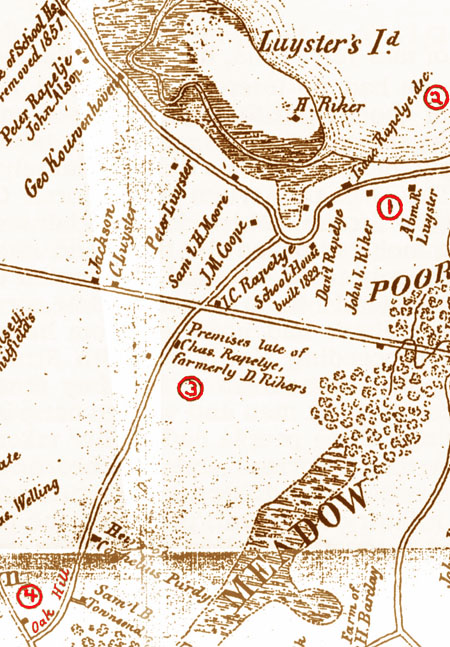
 | Part #6 of 12 (so far): NYCHS presents excerpts from The Rikers: Their Island, Homes, Cemetery and Early Genealogy in Queens County, NY by permission of its author, an 11th generation Abraham Rijcken vanLent descendant, Edgar Alan Nutt. | 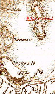 |
In the two hundred and a half or so years in which members of the Riker
family were both plentiful and prominent in the Newtown area they lived in or
established many homes, the location of most of which are no longer known.
Various
of these are referred to in James Riker’s The Annals, and a few are indicated
on nineteenth century maps, whether as specific locations shown by small black dots
or as the outlined property or estate on which the home somewhere existed.
Some of
these are mentioned below, in passing, in the genealogical chapter.
Two particular
homes, however, have long been associated with the family; one existed until early last century and as an historic building has been well- documented; and the other
remains as possibly the oldest private home in New York City, and is remembered as
related to the family by its proximity to the family cemetery. Records and facts
regarding these two homes, and of two other significant Riker homes about which all
too little is known, follow.
In a Dutch patent dated February 26, 1654, immigrant Abraham Rycken
received a grant of land that turned out to be in the Poor Bowery or Poor Farm, in
Dutch “de Armen Bouwerie,” described by [James] Riker as “an extensive farm then in
progress, in the occupation and tenure of the deacons and officers of the Dutch
Church at New Amsterdam; and by them kept under cultivation for the benefit of the
poor.”
Representatives of the Dutch Church on June 3, 1655, complained that part of
their Poor Bowery had been given to Abraham Rycken; they were not interested in
disturbing him since they considered him (surprisingly) to be “a poor man who has
no more than he can earn with his hands;” but he had closed off a public road that
they wanted to have reopened.
His grant however was good, and, although he was
in court many times in matters pertaining to property, it was this farm in the Poor
Bowery that remained in the family for most of the time over the course of almost
three centuries and that was the site of the family homestead.
While no early
reference or description exists as to any buildings that Abraham put up, there
should be no doubt that he in fact did erect a house and farm buildings of some sort.
According to an April 24, 1935, report of the Historic American Buildings Survey, “much still remain(ed) of the original structure” in the later Riker Homestead
Mansion, and “It (was) built in the old Dutch style, long and narrow. It was, no doubt,
originally one story with a pitch or gambrel roof.”
As will appear later the mansion
in its hey day bore no resemblance to that early Dutch farmhouse which perhaps
resembled the Lent-Rapelye farm house, the second of the homes to be considered,
below.
Abraham and his wife brought six children with them when they moved to
their new farmstead in Newtown, and subsequent to the move they added two or possibly three more.
When he died in 1688 all of his surviving children had reached
their majority; in his March 9, 1688, will he named and bequeathed specified sums
to Ryck, Jacob, Mary, John, Aletta, and Hendrick; and he left the residue of his estate
to his son Abraham and named him his executor.
This disposition of his estate both
broke with the customary practice of primogeniture under which Ryck as the eldest
would have been the heir and it appeared to demonstrate favoritism toward Abraham
who was the next to the youngest of the sons.
The reason for this may seem to have
been in part the fact that Ryck and Hendrick both adopted the Lent surname in place
of that of Rycken in one of its forms, but that surname change was not used by them
for as much as several decades later; and the actual reason probably lay in the fact
that Abraham was the only son remaining on the farm.
The younger Abraham was enterprising and successful such that in 1688 he
was able to buy a third of the Tuder Patent which extended westerly from the
paternal farm toward the Hellgate area of the East River, but the really notable mark
of his prosperity was the house, a veritable mansion, which he erected in about 1700
either de novo or more likely as an addition to and an improvement upon his father’s
house. This building, however, was not quite identical with the subject of the above
referenced HABS report, the historic building which it documented in full in 1935.
Abraham [the son] lived a long life, from December 26, 1655, to August 20, 1746, and
toward the end of his ninety-plus years he was completely blind. A legend
concerning his final day has been repeated or referred to many times.
It seems that
he was sitting under a pear tree near the house and was musing over never having
seen some of his grandchildren. His eye sight suddenly returned, his wish was
fulfilled, and upon returning to the pear tree he died.
Almost thirteen years earlier,
however, perhaps when his eye sight had deteriorated to the point that he was no
longer able to manage his properties, he sold four properties including the
homestead farm and mansion to his sons Abraham and Andrew for three
hundred pounds.
The dating of the indenture includes “in the seventh year of the
Reign of our Sovereign Lord George by the Grace of God of Great Brittain France and
Ireland King Defender of ye Faith,” and his residence is specified as on “Nassaw
Island in the Colony of Newyork.” The properties conveyed thereby in fee simple
were:
Less than a year later, and well before [their father] Abraham’s death, the two sons came
to an agreement as to the division of the tracts that they had bought from their
father.
In a covenant dated May 11, 1739, [son/brother] Abraham “quit claim unto Andrew
Rycken... all such estate right interest.., whatsoever which ye said Abraham Rycken
had.., to that one equal half of those lands & meadows which Abraham Rycken senr...
did... transfer.., unto the said Abraham & Andrew Rycken.” Specifics of the agreed
division are then stated as follows:
The latter item and its provision imply that Andrew executed a similar
document in which he ceded to Abraham his claim to various parts of the total
properties, but no such document has been located. It may be assumed, however, that
there was such and that the consequence of the two documents was that Andrew had
the homestead farm and mansion, the small wood land, and the easterly half of the
island and that Abraham had all else.
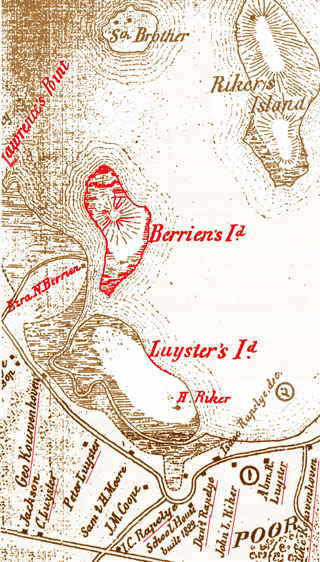
What subsequently occurred with regard to
Abraham’s share, other than with regard to Riker’s Island as discussed in its relevant
chapter, is the subject of the discussion below of the third home.
Consideration of the vicissitudes of the mansion with its farm continues with regard
to Andrew and the heirs and assigns, but first there is the matter of Andrew’s
enlarging the homestead farm in two purchases.
On April 5, 1740, he paid £42.6s to
Moore Woodward for fourteen acres and 150 rods of meadow land, and on May 8, 1746,
he paid £13.4s to Lambert and Joseph Woodward for five and three-quarters acres of
meadow land.
The 1739 document indicated a Woodward of unspecified given name as
an abutter, and on this basis it is likely that the foregoing two parcels abutted the
homestead farm. Possibly Moore Woodward was the 1739 abutter and that the other
two Woodwards were his sons or heirs.
If the reference to rods is taken to be square
rods, then 150 rods is .93 75 of an acre making the land acquired in the two purchases
to be 20.6875 acres.
Such an exactness is quite improbable, but, together with the
fifty-two or “about forty-nine” acres and the two and a half woodland acres, it made
the farm to be about seventy-three or seventy-four acres in total.
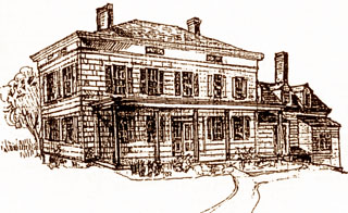
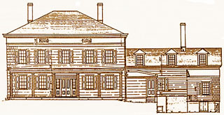
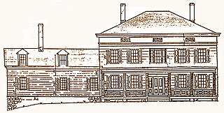
In about 1750 a fire ruined part of the house, however the “mansion was
immediately erected on the same site, which contained considerable of the original
building.” Another source claimed that at about that time, and no doubt
following the fire, “an extra story was added, and a front and rear porch with rows of
Corinthian pillars.” The resulting mansion was the third house or at least the third
version of the original house with the second and third versions incorporating the
previous elements; but the available pictures, drawings, and descriptions are all of
the third version.
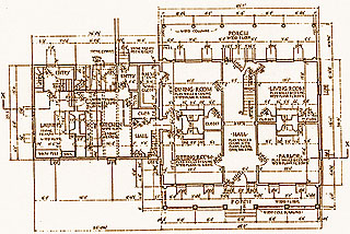
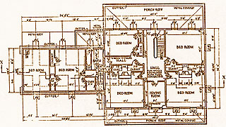
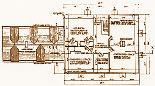
The resulting mansion had eighteen rooms including space for
three on the top floor that were unfinished, there were eight bedrooms, and there were many closets and hallways and spaces of unspecified purposes that in effect
were additional rooms. Three chimneys served the house but perhaps strangely only —
two of the bedrooms had fireplaces. Notable features included three stairways
between the first and second floors; a large wine closet off of the dining room; a
second floor bathroom equipped only with a bathtub, pump, and tank; a laundry, and a
sewing room.
The main rooms on the first and second floors had cornices of varying U
designs, more elaborate, as also in the case of the woodwork, on the former than the
latter. In addition to the two bedroom fireplaces there were six others: each of the
four main first floor rooms was equipped with one, the laundry had one, and the
kitchen had a massive one fitted out with a built-in cast iron stove consisting of a fire
box for burning coal, an oven on either side, the stove top, and up one side two —
chambers that may have been warming ovens.
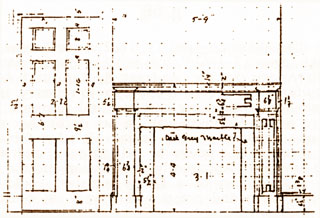
The fireplace mantles varied
according to the importance of the rooms with the parlor mantle the most elaborate _
and featuring in its quasi-tympanum relief a reclining Apollo with harp. In 1934 the
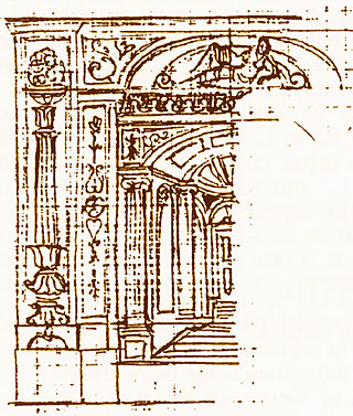
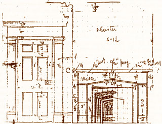
Historic American Buildings Survey made a complete architectural record of the
mansion, both interior and exterior, resulting in many dozens of sketches of various
aspects of the building and of its details plus eleven measured architectural drawings ~
and several photographs. The following drawings, somewhat reduced in size, sample
the collection and show the mansion’s scale and importance.
Andrew died either on April 11, 1762, or on February 12, 1763, having
made his will dated August 17, 1761. It is notable that his name appears in three
versions in the will: Andris Rycker, Andreas Rycken, and Andrew Rycken. He
provided handsomely for his wife even if she were to remarry. . . . but “if any of my servants
misbehave I hereby give her the power to sell the same and have the use of the
money during her widowhood.”
Apparently the mansion and the farm, together with
the personal needs and comfort of a family member, could only be met and
maintained by the institution and practice of slavery. In contrast to his attitude
toward his servants, Andrew treated his four children equally and considerately, at
least with regard to money: each would receive or had received £100, and the residue
of the personalty was to be divided equally among the four following their mother’s
death (which would not be until September 26, 1775).
He ordered that his real estate
was to be sold following his youngest son Samuel’s coming of age (he was born on
April 8, 1743), preferably among the three sons to the highest bidder of them.
Samuel and his older brother Abraham formed a consortium and
made the winning bid of £1760 for the homestead farm and mansion. In accord with
their father’s will siblings John Berrien and Ruth on May 16, 1765,
conveyed and released the farm to the winning brothers. Almost four years later
on January 27, 1769, the consortium was dissolved with Abraham, together with his
wife Margaret, selling his share to Samuel for £900. Samuel thus became the sole
owner of the mansion and farm, and over time he enlarged the farm.
In a deed
dated April 30, 1793, for 10 shillings Richard Lawrence and his wife Mary quitclaimed
to Samuel a swamp and other property of unspecified acreage.
Richard Lawrence was
Samuel’s wife Anna’s only sibling.
In a deed dated March 28, 1811, Samuel paid $75
for two and a half acres of meadow land. The seller was Daniel and his wife
Deborah;
Daniel was the grandson of Abraham, and the small parcel appears to
have been part of tracts remaining to Abraham as a result of the 1739 covenant or
covenants discussed above. Probably it abutted the homestead farm.
The 1793 deed
appears to have caused a title problem because on October 16, 1821, two deeds were
made, one reversing the other.
In one Samuel and Anna his wife for one dollar
deeded the swamp to their son John L. Riker, and in the second John L
Riker and his wife Maria for one dollar deeded the swamp back to Samuel.
Samuel
died on May 19, 1823 and left a very large estate plus a very long will dated October
16, 1821, the same date as the two concurrent deeds next above.
Among many
provisions the will made John. L. the inheritor of the homestead farm and mansion.
The widow Anna and the other children on June 11, 1823, quitclaimed their interest
in the property to John L., and Samuel’s estate was finally settled on June 7, 1826.
John L. thereby became the owner of the farm and mansion and occupied the latter
until his death in 1861.
John L. Riker was survived by his second wife, Lavinia Smith, who died on
December 15, 1875. Possibly she remained in the mansion during the fourteen years
of her widowhood, and if so she probably was the last Riker occupant.
A newspaper
article from about 1934 or 1935 reported that it was then more than sixty years
since the last Riker lived there.
Possible the mansion was rented out after Lavinia’s
departure, but by the late 1880s a tenant farmer, together at least with his sister in
later years, lived in “the most ancient wing of the ancient house.”
As late as 1930s
they were still in the house with him, Cy Mitchell, no longer doing much farming of
the 120 acre property and instead taking care of the nearby family cemetery.
In
September, 1931, there was another caretaker of the cemetery, this one living in the
nearby Lent-Rapelye house, suggesting that the Mitchells had gone from the
mansion.
It was at about this time that the property was put up for sale by the still
existent John L Riker Estate.
A July 12, 1934, article reported that a federal agency,
the Historic American Buildings Survey, was at work and would include the Riker
Mansion.
The survey was completed and reported on April 24, 1935, as HABS No. 4-29
(as per above) consisting of eleven detailed architectural drawings of the exterior
and interior, many sketches of details, plus three photographs of which two are of
the exterior and the third the massive kitchen range built into the fireplace.
The 1930s were the decade of the building of the Triborough Bridge and the
LaGuardia Airport, the former completed in 1936 and the latter in 1939.
Both had an
impact on the Riker property.
The bridge opened up easy access to the Newtown area
of Long Island with resulting pressure on available land.
This no doubt would have
taken the Riker land if it were not for the airport.
During the construction phase there
were opposing plans for the mansion: it was either to be torn down or, as favored by
the company’s president, William F. Carey, it was to be turned into a clubhouse.
What
to do with the mansion was resolved, however, by a fire that occurred on March 25,
1939.
An Astoria policeman spotted smoke and turned in an alarm, most of the
Astoria fire equipment responded, but the fire was beyond control after 2000 feet of
hose were laid from the nearest fireplug.
Nothing was saved from the building, and
after the fire a single chimney and the cellar were all that remained.
The site now
lies beneath the surface of LaGuardia Airport with nothing to suggest that the
homestead farm and the Riker Mansion ever existed.
|
Correction History Society |
Queens Historical Society |
Island was 'Camp Astor' |
Astoria Historical Society |
Ridgewood Historical Society |
|
Rikers Island's role in NY correction history warrants our providing material on its "pre-Correction" background that is so bound up with Rikers family history. Bishop Nutt's book serves as an excellent vehicle for doing that. His approach is not exclusively or narrowly genealogical. More than simply tracing lineage, he places his family history in wider chronological and geographic contexts through which his exhaustive research tracked it, thus reflecting much other history -- of the island, county, city and country. Strictly genealogical citations, notes, and codes in the printed book have been reduced or dropped in these excerpts. This presentation includes a book print copy information page. NYCHS retains and reserves all rights to images of photos it took during the June 5, 2005 homestead tour and the September 1998 Samuel Perry Center dedication and their captions as well as captions of inserted images not taken from the printed book. | ||||