Chapter I excerpts: 1816 - Jacob Radcliffe, Mayor
Something of [Nathan] Hale's spirit (we hope it may not seem fantastic to say) appears
to be passing, however feebly or slowly, into the blood of New Yorkers.

|
|
Charles Haswell began his Reminiscences by invoking the patriotic spirit of Nathan Hale whose statue stands in City Hall Park. Throughout this excerpt edition, images and notes appearing in blue and orange boxes such as this have been added by the NYCHS webmaster to enchance the presentation. Images not in these blue and orange boxes were in the original work and in Hal Morris' web rendition of it. Certain paragraphs in this NYCHS excerpts edition have been boldfaced to call attention to them. They relate directly to correction and other criminal justice matters.
|
Again they are caring for their city, as did their forefathers, with a
nourished pride, not merely in her growth, her luxury and splendors, her
unexampled financial credit and marvellous reach of business transactions,
but also in her history and traditions.
To forward this good work is the main purpose of this
volume, wherein some of the earlier recollections of eighty years are set
down, while yet time and strength serve for that purpose. . . .
I have held rather closely to dates, as
they appear in my notebooks, somewhat to the detriment of literary
form, but on the whole concluding that order to be a needful clue for myself
and my readers to follow through the wilderness of years. . . . .
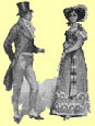
Readers of the present day may imagine for themselves
the conditions of New York in 1816, on considering the fact that at that
date the limits of the city as indicated by its dwellings, with the exception
of a cluster of houses, etc., at the locations known as
- Harlem (110th to 136th Street);
- Greenwich Village
(Perry to Horatio Street, and Bleecker Street to the river);
- Bloomingdale,
or Harsenville (on Broadway, from 66th to 73rd Street);
-
Manhattanville (about Manhattan Street);
- Yorkville (in the vicinity of
86th Street and 3rd Avenue); and
- "Manhattan Island,"
as it was termed (a part of the mainland being intersected by
a marsh in the vicinity of the shipyards on the East River, from Rivington
to 10th Street),
were clearly defined to be below Canal Street on the
west, and irregularly below Prince and Rivington streets on the east side;
its population being 93,634, and very few of its citizens enjoying the
luxury of maintaining their own carriages.
|
|
Lispenard's
Meadows
|
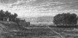
Lispenard's
Meadows, originally extending from Duane Street on the south to Broome
Street on the north bounded on the east by Broadway and on the west by
the North River, were but partly filled in, and Canal Street
was then in process of grading, being crossed at Broadway over a bridge
of masonry universally known as the "Stone Bridge;"
a publichouse on Broadway, near Walker Street, being known as the
Stone Bridge Hotel.
|
|
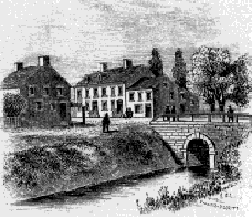
Stone Bridge
|
ExMayor Daniel F. Tiemann writes me that he has
often skated under this bridge.
As late as 1820 I,
in company with an elder relative occasionally practiced pistolshooting
at a target on a fence on the south side in this open and unfrequented
street, between Broadway and Mercer Street. . . .
At the time here under mention the principal fronts of
the blocks on Broadway, on the west side between Franklin and White streets,
and on the east side between White and Walker streets, were in primitive
soil, and enclosed with board fences.
Many of the older streets still retained names now forgotten.
|
Update note:
|
|
The Western Union Building at 60 Hudson St., where NYC DOC's headquarters is situated, stands at the south end of what was Lispenard's Meadows mentioned above. The Manhattan Detention Complex aka the Tombs is situated at The Collect mentioned below.
|
The craze for a change, so familiar to New Yorkers of modern date in
their loss, for example, of Amity, Anthony, Bancker, Chatham, and Robinson
streets (to name only the first that come to mind), has swept away ancient
designations that they know not of.Thus, in earlier times, South William
Street was known as "Dirty Lane;" Cliff, as "Elbow
Street;" Nassau, originally as "Pie Woman's Lane;"
Beaver, as "Slaughterhouse Lane;" Broad, as "Smell
Street;" Elm, as "Republican Alley;" Washington
Place, from University Place to Fifth Avenue, as "Shinbone Alley."
Hanover Street was "Slote Lane;" Exchange Place was
"Garden Street" from Hanover to Broad, and thence to Broadway was
called "Flat and Barrack Hill," this descent being then
a favorite place of boys for "coasting." . . . .
The Collect -- that is, the pond that had been bounded
by White, Bayard, Elm, Canal, and Pearl streets, which naturally had discharged into the East River through "Wreck Brook," across the
region still known as "The Swamp," but had been diverted
into the North River through a drain cut on the line of Canal Street, passing under the Stone Bridge-was but
partly filled in.
Many primeval streams and water courses existed upon this
island of Manhattan. . Most of them have been filled up, and their flow
checked and diverted; but though not apparent now, they still exist, and
except for the area covered by buildings and pavements, with the artificial
leadingoff of rain and snowwater, would appear in their original
force.
Canal Street:
when this great thoroughfare was
filled in, it became necessary to continue the original stream or water
course through it in a sewer, which led from Centre Street to the river;
and whenever it became necessary to clean its bottom, prisoners from Bellevue
were employed, the vicious being restricted by an iron ball and chain secured
to one or both of their legs.
Lispenard's Meadows,
as well as the site of Tompkins Square, were good snipe grounds; while
the various suitable places above them, notably the site of Central Park
and the low ground between it and the East River, furnished ample extent
for an entire day's shooting . . . .
The Battery, sed quantum mutatus ab illo was the sea breathingspot, and,
in proportion to the number of citizens, it was much more frequented than
Central Park is at the present period of 1895. It was bounded seaward by
a riprap wall between it and Fort Clinton, now Castle Garden, and
very far inside of the present extension. A bridge about two hundred feet
in length connected the shore and the fort. The area of the Battery was
extended and walled in at a later period (about 1823), and again extended
and walled in in 1856. It was the afternoon resort of children, and in
summer the evening resort and promenade of citizens. Ladies could visit
it with impunity, even when unaccompanied by a gentleman.
Castle Garden has an interesting history; erected
in 1814, and first named Fort Clinton, the result of a massmeeting
held in the City Hall to consider the best means of fortifying the city
should the war with England extend northward. During its construction a
patriotic dame of high social position trundled a wheelbarrowful of earth
from Trinity Churchyard down Broadway to the fort.
When the property was ceded back to the city by the Federal
Government in 1822, in consequence of the removal of military headquarters
to Governor's Island, it was determined to convert Fort Clinton (or Castle
Clinton) into a place of public amusement, and as such, under the now
familiar name of Castle Garden, it long fulfilled its purpose admirably,
and is well remembered as the home of the opera and the scene of Jenny
Lind's extraordinary triumphs. . . .
On the east side of Greenwich Street, near the Battery,
was the Atlantic Garden, a wellconducted and popular resort
of the time.
In line with the foot of Hubert Street, a waterfort
stood some two hundred feet out in the river, approached by a bridge, which,
like the Battery, was a favorite resort for the dwellers of the vicinity
on summer evenings.
|
|
Bridewell, West Side, City Hall
|
This fort, built of freestone, was known as the "Red
Fort," while one at the foot of Gansevoort Street, being whitewashed,
was called the "White Fort." . . . .
The State's Prison building and ground occupied about
four acres in Washington, bounded by Christopher, Perry, and West
streets, surrounded by a high stone wall, guarded by sentries. An extensive
brewery now occupies the site of this building.
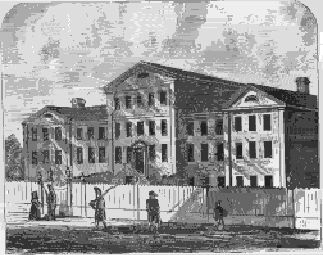
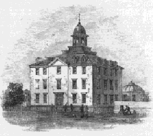
The City Prison, or Bridewell, stood on Broadway in line
with the present City Hall, and the Jail,
or Debtors' Prison, alike in line with it at its opposite end, where it
still stands, converted into the Hall of Records, the veritable
though altered structure of the old jail changed into a really beautiful
form, though now bearing an unsightly wooden top. Between those buildings,
where now is the new Court House, was the Almshouse on Chambers Street. . . .
|
|
Hall of Records, our old jail.
|
In May the Penitentiary adjoining the new Almshouse at
Bellevue was first occupied, and the convicts therein were employed in
the opening and improvement of contiguous roads
and streets.
The markets were the Fly (Vlie or Vly, an abbreviation
of valley), located at the foot of Maiden Lane, which was this year ordered
to be removed;
the Washington, at foot of Vesey and Fulton
streets, on the site of the Bear (1814), by
which name the Washington was known for many years; the Catharine,
at foot of the street of that name; the Old Slip, at foot of William Street,
afterwards the Franklin; the Duane, at foot of the street so named;
the Collect, on the south side of White Street, near Broadway and
Cortlandt Alley (removed in 1818); the
Greenwich, foot of Christopher Street; and the Gouverneur,
foot of that street, erected at the individual cost of Christian Bergh,
the shipbuilder in Water Street; and one at the foot of Grand Street.
The Grand Market Place, which embraced Tompkins
Square, bounded on the north by Tenth Street, south by Seventh Street,
east by the river, and west by Avenue A, was laid out in 1807 by three commissioners, Gouverneur Morris, Simon De
Witt, and John Rutherfurd, but subsequently was abolished by an Act of
the Legislature.
|